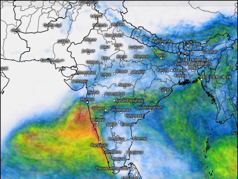
હવામાન વિભાગે આગાહી કરી છે કે 25 મે સુધીમાં કેરળમાં ચોમાસુ આવી શકે છે. ચોમાસાનું વહેલું આગમન પણ ખેડૂતો માટે સારો સંકેત છે. તે જ સમયે દિલ્હી-NCRમાં વરસાદથી લોકોને ભેજ અને ભીષણ ગરમીથી રાહત મળી છે. હવે હવામાન વિભાગે અરબી સમુદ્રમાં ઓછા દબાણની ચેતવણી જારી કરી છે. આના કારણે કોંકણથી મહારાષ્ટ્ર અને ગુજરાત સુધી ભારે વરસાદની શક્યતા છે. આની અસર કર્ણાટકની રાજધાની બેંગલુરુ અને કેરળ પર પણ પડી શકે છે.
હવામાન વિભાગ (IMD) એ જણાવ્યું હતું કે જેમ અરબી સમુદ્રના પૂર્વ-મધ્ય ભાગમાં નીચા દબાણની આગાહી કરવામાં આવી હતી, તેમ જ બન્યું. દક્ષિણ કોંકણ અને ગોવાના દરિયાકાંઠા નજીક એક ઓછા દબાણનું ક્ષેત્ર રચાયું છે.
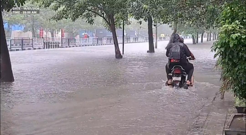
આ સિસ્ટમ આગામી 24 કલાકમાં ડિપ્રેશનમાં ફેરવાઈ શકે છે. આ સિસ્ટમ આગામી બે દિવસ સુધી કોંકણ કિનારાની નજીક રહેશે અને તેના કારણે કોંકણ-ગોવા સહિત પશ્ચિમ કિનારા પર ભારે વરસાદ અને વાવાઝોડા થવાની સંભાવના છે. હવામાન વિભાગનો એવો પણ અંદાજ છે કે આ ડીપ ડિપ્રેશન આગામી 36 કલાકમાં ગુજરાતના કચ્છ કિનારા તરફ આગળ વધી શકે છે.હવામાન વિભાગ (IMD) એ આ સપ્તાહના અંતે ફરી વરસાદ અને વાવાઝોડાની આગાહી કરી છે. હવામાન વિભાગની આગાહી મુજબ દિલ્હીમાં વાદળછાયું અને તોફાની વાતાવરણ રહેવાની શક્યતા છે. આનાથી વધતી ગરમીથી થોડી રાહત મળશે. મહત્તમ તાપમાન 37 ડિગ્રી સેલ્સિયસની આસપાસ રહેવાની ધારણા છે. જોકે ભેજ થોડું હેરાન કરશે.
આગામી દિવસોમાં દિલ્હીવાસીઓ વધતા તાપમાન અને તોફાની હવામાનનો સામનો કરી શકે છે. રાજધાની આંશિક રીતે વાદળછાયું રહેશે અને ક્યારેક ગાજવીજ સાથે વરસાદ પડી શકે છે. હવામાન વિભાગના જણાવ્યા અનુસાર 28 મે સુધી શહેરમાં હવામાનમાં વધઘટ રહેશે. 26 અને 28 મેના રોજ મહત્તમ તાપમાન 40 ડિગ્રી સેલ્સિયસ સુધી પહોંચી શકે છે.
દેશના અન્ય ભાગોમાં હવામાનની સ્થિતિ
આગામી 7 દિવસ સુધી ઉત્તર-પૂર્વ ભારતમાં હળવાથી ભારે વરસાદની આગાહી છે. આ દરમિયાન તોફાન અને વીજળી પડવાની શક્યતા છે.
26 મે સુધી પશ્ચિમ બંગાળ, સિક્કિમ, મધ્યપ્રદેશ, વિદર્ભ, છત્તીસગઢ, ઓડિશા અને બિહારમાં વાવાઝોડાની શક્યતા છે.
કેટલાક વિસ્તારોમાં વીજળી પડવાની અને 40-50 કિલોમીટર પ્રતિ કલાકની ઝડપે પવન ફૂંકાવવાની શક્યતા છે.
23 મે એટલે કે આજે પશ્ચિમ મધ્યપ્રદેશ, ઝારખંડ અને છત્તીસગઢમાં તોફાન આવવાની શક્યતા છે.
ઉત્તરાખંડ, હિમાચલ પ્રદેશ, ઉત્તર પ્રદેશમાં 28 મે સુધી વાવાઝોડા, વીજળી અને 40-50 કિમી પ્રતિ કલાકની ઝડપે ભારે પવન સાથે છૂટાછવાયા વરસાદની શક્યતા છે.
જમ્મુ અને કાશ્મીર, પંજાબ, હરિયાણા, ચંદીગઢ અને રાજસ્થાનમાં આજે અને કાલે 50 કિમી પ્રતિ કલાકની ઝડપે વાવાઝોડા, વીજળી અને ભારે પવન સાથે વરસાદ થવાની સંભાવના છે.
23 અને 24 મેના રોજ પશ્ચિમ રાજસ્થાનમાં ધૂળની આંધી અને 25 અને 26 મેના રોજ પૂર્વ રાજસ્થાનમાં વાવાઝોડા સાથે વરસાદ પડવાની શક્યતા છે.
The Meteorological Department has predicted that monsoon may arrive in Kerala by May 25. The early arrival of monsoon is also a good sign for farmers. At the same time, rain in Delhi-NCR has given relief to people from humidity and intense heat. Now the Meteorological Department has issued a low pressure warning in the Arabian Sea. Due to this, there is a possibility of heavy rains from Konkan to Maharashtra and Gujarat. This may also affect Karnataka's capital Bengaluru and Kerala. The Meteorological Department (IMD) said that as the low pressure was predicted in the east-central part of the Arabian Sea, it happened. A low pressure area has formed near the coast of South Konkan and Goa. This system may turn into a depression in the next 24 hours. This system will remain close to the Konkan coast for the next two days and due to this, there is a possibility of heavy rain and thunderstorms on the west coast including Konkan-Goa. The Meteorological Department also estimates that this deep depression may move towards the Kutch coast of Gujarat in the next 36 hours. The Meteorological Department (IMD) has predicted rain and thunderstorms again this weekend. According to the Meteorological Department's forecast, there is a possibility of cloudy and stormy weather in Delhi. This will provide some relief from the rising heat. The maximum temperature is expected to be around 37 degrees Celsius. However, the humidity will be a little annoying.
Delhiites may face rising temperatures and stormy weather in the coming days. The capital will remain partly cloudy and there may be occasional rain with thunder. According to the Meteorological Department, the weather in the city will fluctuate until May 28. The maximum temperature may reach 40 degrees Celsius on May 26 and 28.
Weather conditions in other parts of the country
Light to heavy rains are forecast in North-East India for the next 7 days. Thunderstorms and lightning are likely during this time.
Thunderstorms are likely in West Bengal, Sikkim, Madhya Pradesh, Vidarbha, Chhattisgarh, Odisha and Bihar till May 26.
Thunderstorms and winds gusting up to 40-50 kmph are likely in some areas.
Thunderstorms are likely in West Madhya Pradesh, Jharkhand and Chhattisgarh on May 23 i.e. today.
Thunderstorms, lightning and scattered rains with gusty winds gusting up to 40-50 kmph are likely in Uttarakhand, Himachal Pradesh, Uttar Pradesh till May 28.
Thunderstorms, lightning and gusty winds gusting up to 50 kmph are likely in Jammu and Kashmir, Punjab, Haryana, Chandigarh and Rajasthan today and tomorrow.
There is a possibility of dust storms in West Rajasthan on May 23 and 24 and thunderstorms in East Rajasthan on May 25 and 26.
 હોમ
હોમ
 બ્રેકિંગ ન્યૂઝ
 हिंदी समाचार
 ભારત
ભારત
 ગુજરાત
 ચુંટણી ૨૦૨૪
 દુનિયા
 રાજનૈતિક
 સામાજીક
 સિનેમા, TV અને OTT
 ઇવેન્ટ્સ
 સોશિયલ મીડીયા
 કલા અને સંસ્કૃતિ
 રંગોના તરંગો
 ધર્મ
ધર્મ
 રમત-ગમત
 વેપાર
વેપાર
 ટેકનોલોજી
 ઇતિહાસ
 વાઇલ્ડલાઈફ
 લાઈફ સ્ટાઈલ
 રસોઈ-વાનગી
 વિશેષ વાંચન
 સપર્ક
સપર્ક
 અમારા વિષે